Atlas 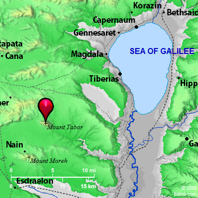 Tabor (Mount Tabor) and surrounding area
Maps Created using Biblemapper 3.0Additional data from OpenBible.infoOccurrences Joshua 19:22 The border reached to Tabor, Shahazumah, and Beth Shemesh. Their border ended at the Jordan: sixteen cities with their villages. Judges 8:18 Then said he to Zebah and Zalmunna, "What kind of men were they whom you killed at Tabor?" They answered, "They were like you. Each one resembled the children of a king." Jeremiah 46:18 As I live, says the King, whose name is Yahweh of Armies, surely like Tabor among the mountains, and like Carmel by the sea, so shall he come. Hosea 5:1 "Listen to this, you priests! Listen, house of Israel, and give ear, house of the king! For the judgment is against you; for you have been a snare at Mizpah, and a net spread on Tabor. Encyclopedia TABOR, MOUNT(tabhor, har tabhor; oros Thabor, to Itaburion): This mountain seems to be named as on the border of Issachar (Joshua 19:22). It is possibly identical with the mountain to which Zebulun and Issachar were to call the peoples (Deuteronomy 33:19). Standing on the boundary between the tribes, they would claim equal rights in the sanctuary on the top. The passage seems to indicate that it was a place of pilgrimage. The worshippers, bringing with them the "abundance of the sea" and the "treasures of the sand," would be a source of profit to the local authorities. The mountain can be no other than Jebel et-Tur, an isolated and shapely height, rising at the northeast corner of the Plain of Esdraelon, about 5 miles West of Nazareth. The mountain has retained its sacred character, and is still a place of pilgrimage, only the rites being changed. The present writer has mingled with great interest among the crowds that assemble there from all parts at the Feast of the Transfiguration.
It was on the summit and slopes of this mountain that Deborah and Barak gathered their forces; and hence, they swept down to battle with Sisera in the great plain (Judges 4:6, 12, 14). Here probably the brothers of Gideon were murdered by Zeba and Zalmunna (Judges 8:18). Moore ("Judges," ICC, at the place) thinks the scene of the slaughter must have been much farther South. He does not see what the brothers of Gideon were doing so far North of their home in Abiezer. There is, however, no reason for placing Ophrah so far to the South as he does; and in any case the men were probably captured and taken to Tabor as prisoners. Josephus (Ant., VII, ii, 3) says it was in one of Solomon's administrative districts (compare 1 Kings 4:17). Such a prominent and commanding position must always have invited fortification. In the time of Antiochus the Great, 218 B.C., we find a fortress here, which that king took by stratagem, Atabyrion by name (Polyb. v. 70, 6). It was recovered by the Jews, and was held by them under Janneus, 105-70 B.C. (Ant., XIII, xv, 4). The place fell to the Romans at the conquest under Pompey; and not far from the mountain Alexander, son of Aristobulus II, suffered defeat at the hands of Gabinius, proconsul of Syria, 53 B.C. (Ant., XIV, iv, 3; BJ, I, viii, 7). Josephus, who commanded in Galilee at the outbreak of the Jewish war, recognized the importance of the position, and built a wall round the summit. After the disaster to Jewish arms at Jotapata, where Josephus himself was taken prisoner, many fugitives took refuge here. Placidus the Roman general did not attempt an assault upon the fortress. Its defenders were by a feint drawn into the plain, where they were defeated, and the city surrendered.
A tradition which can be traced to the 4th century A.D. places the scene of the Transfiguration on this mountain. Allusion has been made above to the sacred character of the place. To this, and to the striking appearance of the mountain, the rise of the tradition may have been due. Passing centuries have seen a succession of churches and monasteries erected on the mountain. The scene of the Transfiguration was laid at the southeastern end of the summit, and here a church was built, probably by Tancred. Hard by was also shown the place where Melchizedek met Abraham returning from the pursuit of Chedorlaomer. The mountain shared to the full the vicissitudes of the country's stormy history. In 1113 A.D. the Arabs from Damascus plundered the monasteries and murdered the monks. An unsuccessful attack was made by Saladin in 1183, but 4 years later, after the rout of the Crusaders at Hattin, he devastated the place. Twenty-five years after that it was fortified by el-Melek el-`Adel, brother of Saladin, and the Crusaders failed in an attempt to take it in 1217. In 1218, however, the Saracens threw down the defenses. Sultan Bibars in 1263 ordered the destruction of the Church of the Transfiguration, and for a time the mountain was deserted. The Feast of the Transfiguration, however, continued to be celebrated by the monks from Nazareth. During the last quarter of the 19th century much building was done by the Latin and Greek churches, who have now large and substantial monasteries and churches. They have also excavated the ruins of many of the old ecclesiastical buildings. The remains now to be seen present features of every period, from Jewish times to our own.
Mt. Tabor rises to a height of 1,843 ft. above the sea, and forms the most striking feature of the landscape. Seen from the South it presents the shape of a hemisphere; from the West, that of a sugar loaf. Its rounded top and steep sides are covered with thick brushwood. It is about half a century since the oak forest disappeared; but solitary survivors here and there show what the trees must have been. A low neck connects the mountain with the uplands to the North. It is cut off from Jebel ed-Duchy on the South by a fertile vale, which breaks down into Wady el-Bireh, and thence to the Jordan. A zigzag path on the Northwest leads to the top, whence most interesting and comprehensive views are obtained. Southward, over Little Hermon, with Endor and Nain on its side, and Shunem at its western base, we catch a glimpse of Mt. Gilboa. Away across the plain the eye runs along the hills on the northern boundary of Samaria, past Taanach and Megiddo to Carmel by the sea, and the oak forest that runs northward from the gorge of the Kishon. A little to the North of West, 5 miles of broken upland, we can see the higher houses of Nazareth gleaming white in the sun. Eastward lies the hollow of the Jordan, and beyond it the wall of Gilead and the steep cliffs East of the Sea of Galilee, broken by glens and watercourses, and especially by the great chasm of the Yarmuk. The mountains of Zebulun and Naphtali seem to culminate in the shining mass of Great Hermon, rising far in the northern sky. Standing here one realizes how aptly the two mountains may be associated in the Psalmist's thought, although Hermon be mighty and Tabor humble (Psalm 89:12). Tabor is referred to by Jeremiah (46:18), and Hosea alludes to some ensnaring worship practiced on the mountain (5:1).
The present writer spent some weeks on Mt. Tabor, and as the result of careful observation and consideration concluded that the scene of the Transfiguration cannot be laid here. The place would appear to have been occupied at that time; and the remoteness and quiet which Jesus evidently sought could hardly have been found here.
See TRANSFIGURATION, MOUNT OF.
W. Ewing
TA'BOR, a mountain on the n.e. edge of the plain of Esdraelon, 11 ms. a little s. of w. of the s. end of the sea Tiberias, 1843 ft. above the Mediterranean, or about 1500 ft. above the plain and 61 1/2 ms. n. of Jerusalem. It appears like a cone with a flattened top, when viewed from the west. Strong's Hebrew H8396: Tabora mountain Southwest of the Sea of Galilee, also several other places in Isr. |