Encyclopedia
TRACHONITIStrak-o-ni'-tis: Appears in Scripture only in the phrase tes Itouraias kai Trachbnitidos choras, literally, "of the Iturean and Trachonian region" (Luke 3:1). Trachonitis signifies the land associated with the trachon, "a rugged stony tract." There are two volcanic districts South and East of Damascus, to which the Greeks applied this name: that to the Northwest of the mountain of Bashan (Jebel ed-Druze) is now called el-Leja', "the refuge" or "asylum." It lies in the midst of an arable and pastoral country; and although it could never have supported a large population, it has probably always been inhabited. The other is away to the Northeast of the mountain, and is called in Arabic es-Safa. This covers much the larger area. It is a wild and inhospitable desert tract, remote from the dwellings of men. It was well known to the ancients; but there was nothing to attract even a sparse population to its dark and forbidding rocks, burning under the suns of the wilderness. It therefore plays no part in the history. These are the two Trachons of Strabo (xvi.2, 20). They are entirely volcanic in origin, consisting of lava belched forth by volcanoes that have been extinct for ages. In cooling, the lava has split up and crumbled into the most weird and fantastic forms. The average elevation of these districts above the surrounding country is about 30 ft. Es-Safa is quite waterless. There are springs around the border of el-Leja', but in the interior, water-supply depends entirely upon cisterns. Certain great hollows in the rocks also form natural reservoirs, in which the rain water is preserved through the summer months.
El-Leja' is roughly triangular in shape, with its apex to the North. The sides are about 25 miles in length, and the base about 20. The present writer has described this region as he saw it during two somewhat lengthened visits: From Zor`a our course lay Northeast by East.... What a wild solitude it is! Far on every hand stretched a veritable land of stone. The first hour or two of our march no living thing was seen..... Wherever we looked, before or behind, lay wide fields of volcanic rock, black and repulsive,.... with here and there a deep circular depression, through which in the dim past red destruction belched forth, now carefully walled round the lip to prevent wandering sheep or goat from falling in by night. The general impression conveyed was as if the dark waters of a great sea, lashed to fury by a storm, had been suddenly petrified..... At times we passed over vast sheets of lava which in cooling had cracked in nearly regular lines, and which, broken through in parts, appeared to rest on a stratum of different character, like pieces of cyclopaean pavement. Curious rounded rocks were occasionally seen by the wayside, like gigantic black soap bubbles blown up by the subterranean steam and gases of the active volcanic age; often, with the side broken out as if burst by escaping vapor, the mass, having cooled too far to collapse, remained an enduring monument of the force that formed it. Scanty vegetation peeped from the fissures in the rocks, or preserved a precarious existence in the scanty soil sometimes seen in a hollow between opposing slopes. In a dreary waterless land where the cloudless sun, beating down on fiery stones, creates a heat like that of an oven, it were indeed a wonder if anything less hardy than the ubiquitous thistle could long hold up its head..... When the traveler has fairly penetrated the rough barriers that surround eI-Leja' he finds not a little pleasant land within-fertile soil which, if only freed a little from overlying stones, might support a moderate population. In ancient times it was partly cleared, and the work of the old-world agriculturists remains in gigantic banks of stones built along the edges of the patches they cultivated" (Arab and Druze at Home, 30;).
In some parts, especially those occupied by the Druzes, fair crops are grown. Where the Arabs are masters, poverty reigns. They also have an evil reputation. As one said to the present writer, "They will even slay the guest." 'Arab el-Leja' anjas ma yakun is a common saying, which may be freely rendered: "Than the Arabs of el-Leja' greater rascals do not exist." Until comparatively recent years there were great breadths of oak and terebinth. These have disappeared, largely owing to the enterprise of the charcoal burners. The region to the Northeast was described by a native as bass wa`r, "nothing but barren rocky tracts" (compare Hebrew ya`ar), over which in summer, he said, not even a bird would fly. There are many ruined sites. A list of 71 names collected by the present writer will be found in PEFS, 1895, 366;. In many cases the houses, strongly built of stone, are still practically complete, after centuries of desertion.
There may possibly be a reference to the Trachons in the Old Testament where Jeremiah speaks of the charerim, "parched places" (17:6). The cognate el-Charrah is the word used by the Arabs for such a burned, rocky area. For theory that el-Leja' corresponds to the Old Testament "Argob," see ARGOB.
The robbers who infested the place, making use of the numerous caves, were routed out by Herod the Great (Ant., XV, x, 1;; XVI, ix, 1; XVII, ii, 1). Trachonitis was included in the tetrarchy of Philip (viii, 1; ix, 4). At his death without heirs it was joined to the province of Syria (XVIII, iv, 6). Caligula gave it to Agrippa I. After his death in 44 A.D., and during the minority of his son, it was administered by Roman officers. From 53 till 100 A.D. it was ruled by Agrippa II. In 106 A.D. it was incorporated in the new province of Arabia. Under the Romans the district enjoyed a period of great prosperity, to which the Greek inscriptions amply testify. To this time belong practically all the remains to be seen today. The theaters, temples, public buildings and great roads speak of a high civilization. That Christianity also made its way into these fastnesses is vouched for by the ruins of churches. Evil days came with the advent of the Moslems. Small Christian communities are still found at Khabab on the western Luchf, and at Sur in the interior. The southeastern district, with the chief town of Damet el-'Alia, is in the hands of the Druzes; the rest is dominated by the Arabs.
W. Ewing
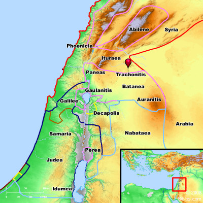
TRACHONI'TIS, a district mentioned in the N.T., n.e. of the Jordan, and one which included the Lejah which is a rough, volcanic part of Trachonitis, called anciently Argob, see map No. 3, and for Trachonitis see map No. 5.
Strong's Greek
G5139: TrachnitisTrachonitis, a rough region South of Damascus