Encyclopedia
GADARAgad'-a-ra (Gadara):
1. Country of the Gadarenes:
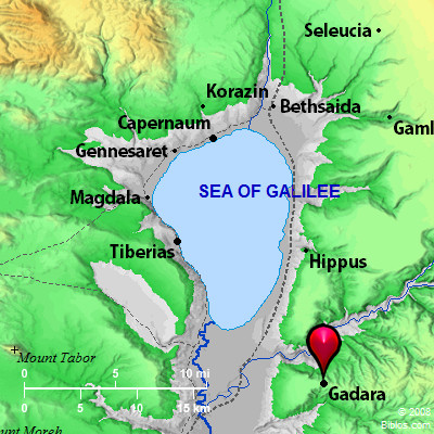
This city is not named in Scripture, but the territory belonging to it is spoken of as chora ton Gadarenon, "country of the Gadarenes" (Matthew 8:28). In the parallel passages (Mark 5:1 Luke 8:26, 37) we read: chora ton Gerasenon "country of the Gerasenes." There is no good reason, however, to question the accuracy of the text in either case. The city of Gadara is represented today by the ruins of Umm Qeis on the heights south of el-Chummeh-the hot springs in the Yarmuk valley-about 6 miles Southeast of the Sea of Galilee. It maybe taken as certain that the jurisdiction of Gadara, as the chief city in these regions, extended over the country East of the Sea, including the lands of the subordinate town, GERASA (which see). The figure of a ship frequently appears on its coins: conclusive. proof that its territory reached the sea. The place might therefore be called with propriety, either "land of the Gerasenes," with reference to the local center, or "land of the Gadarenes," with reference to the superior city.
(NOTE.-The Textus Receptus of the New Testament reading. ton Gergesenon, "of the Gergesenes," must be rejected (Westcott-Hort, II. App., 11).)
2. History:
The name Gadara appears to be Semitic It is still heard in Jedur, which attaches to the ancient rock tombs, with sarcophagi, to the East of the present ruins. They are closed by carved stone doors, and are used as storehouses for grain, and also as dwellings by the inhabitants. The place is not mentioned till later times. It was taken by Antiochus the Great when in 218 B.C. he first invaded Palestine (Polyb. v.71). Alexander Janneus invested the place, and reduced it after a ten months' siege (Ant., XIII, iii, 3; BJ, I, iv, 2). Pompey is said to have restored it, 63 B.C. (Ant., XIV, iv, 4; BJ, I, vii, 7); from which it would appear to have declined in Jewish hands. He gave it a free constitution. From this date the era of the city was reckoned. It was the seat of one of the councils instituted by Gabinius for the government of the Jews (Ant., XIV, v, 4; BJ, I, viii, 5). It was given by Augustus to Herod the Great in 30 B.C. (Ant., XV, vii, 3; BJ, I, xx, 3). The emperor would not listen to the accusations of the inhabitants against Herod for oppressive conduct (Ant., XV, x, 2). After Herod's death it was joined to the province of Syria, 4 B.C. (Ant., XVII, xi, 4; BJ, II, vi, 3). At the beginning of the Jewish revolt the country around Gadara was laid waste (BJ, II, xviii, 1). The Gadarenes captured some of the boldest of the Jews, of whom several were put to death, and others imprisoned (ibid., 5). A party in the city surrendered it to Vespasian, who placed a garrison there (BJ, IV, vii, 3). It continued to be a great and important city, and was long the seat of a bishop (Reland, Palestine, 776). With the conquest of the Moslems it passed under eclipse, and is now an utter ruin.
3. Identification and Description:
Umm Cheis answers the description given of Gadara by ancient writers. It was a strong fortress (Ant., XIII, iii, 3), near the Hieromax-i.e. Yarmuk (Pliny N H, xvi)-East of Tiberias and Scythopolis, on the top of a hill, 3 Roman miles from hot springs and baths called Amatha, on the bank of the Hieromax (Onomasticon, under the word). The narrow ridge on which the ruins lie runs out toward the Jordan from the uplands of Gilead, with the deep gorge of Wady Yarmuk-Hieromax-on the North, and Wady el `Arab on the South. The hot springs, as noted above, are in the bottom of the valley to the North. The ridge sinks gradually to the East, and falls steeply on the other three sides, so that the position was one of great strength. The ancient walls may be traced in almost their entire circuit of 2 miles. One of the great Roman roads ran eastward to Der`ah; and an aqueduct has been traced to the pool of el Khab, about 20 miles to the North of Der`ah. The ruins include those of two theaters, a basilica, a temple, and many important buildings, telling of a once great and splendid city. A paved street, with double colonnade, ran from East to West. The ruts worn in the pavement by the chariot wheels are still to be seen.
That there was a second Gadara seems certain, and it may be intended in some of the passages referred to above. It is probably represented by the modern Jedur, not far from es-Salt (Buhl, Buhl, Geographic des alten Palastina, 255; Guthe). Josephus gives Pella as the northern boundary of Peraea (BJ, III, iii, 3). This would exclude Gadara on the Hieromax. The southern city, therefore, should be understood as "the capital of Peraea" in BJ, IV; vii, 3.
Gadara was a member of the DECAPOLIS (which see).
W. Ewing