Atlas
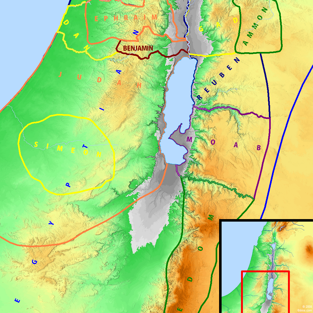
Judah and surrounding region
Maps Created using Biblemapper 3.0Additional data from OpenBible.infoOccurrences
2 Chronicles 16:7 At that time Hanani the seer came to Asa king of Judah, and said to him, Because you have relied on the king of Syria, and have not relied on Yahweh your God, therefore is the army of the king of Syria escaped out of your hand.
Encyclopedia
JUDAH, TERRITORY OF(yehudhah):
I. GEOGRAPHICAL DATA
1. The Natural Boundaries
2. The Natural Divisions of Judah
(1) The Maritime Plain
(2) The Shephelah
(3) The Hill Country of Judah
II. THE TRIBE OF JUDAH AND ITS TERRITORY
III. THE BOUNDARIES OF THE KINGDOM OF JUDAH
LITERATURE
I. Geographical Data.
Although the physical conformation of Western Palestine divides this land into very definite areas running longitudinally North and South, yet all through history there has been a recognition of a further-and politically more important-division into 3 areas running transversely, known in New Testament times as Galilee, Samaria and Judea. These districts are differentiated to some extent by distinctive physical features which have in no small degree influenced the history of their inhabitants.
1. The Natural Boundaries:
The southernmost of these regions possesses on 3 sides very definite natural boundaries: to the West the Mediterranean, to the East the Dead Sea, and the Jordan, and to the South 60 miles, North to South, of practically trackless desert, a frontier as secure as sea or mountain range. On the North no such marked "scientific frontier" exists, and on this the one really accessible side, history bears witness that the frontier has been pushed backward and forward. The most ideal natural northern frontier, which only became the actual one comparatively late in Hebrew times (see JUDAEA), is that which passes from the river `Aujeh in the West, up the Wady Deir Baldt, by the wide and deep Wady Ishar to `Akrabbeh and thence East to the Jordan. A second natural frontier commences at the same line on the West, but after following the Wady Deir Baldt, branches off southward along the Wady Nimr (now traversed by the modern carriage road from Jerusalem to Nablus), crosses the water-parting close to the lofty Tell Ashur and runs successively down the Wady Sanieh and the Wady `Aujeh and by the eastern river `Aujeh to the Jordan. This division-line is one conformable to the physical features, because north of it the table-lands of "Judea" give place to the more broken mountain groups of "Samaria." Another less natural, though much more historic, frontier is that which traverses the Vale of Ajalon, follows the Beth-horon pass, and, after crossing the central plateau near el Jib (Gibeon) and er Ram (Ramah of Benjamin), runs down the deep and rugged Wady SuweiniT, between Jeba` (Geba) and Mukhmas (Michmash), to Jericho and the Jordan. It was along this line that the great frontier fortresses, Bethel, Gibeon, Ramah, Adasa, Geba and Michmash, were erected. Such, on the North, South, East, and West, were the natural boundaries of the southern third of Palestine; yet in all history the land thus enclosed scarcely ever formed a homogeneous whole.
2. The Natural Divisions of Judah:
Within these boundaries lay four very different types of land-the maritime plain, the "lowland" or Shephelah, the "hill country" and, included usually with the last, the desert or Jeshimon.
(1) The Maritime Plain:
The maritime plain, the "land Judah of the Philis" (1 Samuel 6:1; 1 Samuel 27:1 2 Kings 8:2 Zephaniah 2:5), was ideally though never actually, the territory of Judah (compare Joshua 15:45-47); it may have been included, as it is by some modern writers, as part of the Shephelah, but this is not the usual use of the word. It is a great stretch of level plain or rolling downs of very fertile soil, capable of supporting a thriving population and cities of considerable size, especially near the seacoast.
(2) The Shephelah:
The Shephelah (shephelah), or "lowland" of Judah (Deuteronomy 1:7 Joshua 9:1; Joshua 11:2, 16; 15:33-44 1 Kings 10:27 1 Chronicles 27:28 Jeremiah 17:26).-In these references the word is variously rendered in the King James Version, usually as "vale" or "valley," sometimes, as in the last two, as "plain." In the Revised Version (British and American) the usual rendering is "lowland." In 1 Maccabees 12:38, the King James Version has "Shephela" and the Revised Version (British and American) "plain country." The word "Shephelah" appears to survive in the Arabic Sifla about Beit Jebrin.
This is a very important region in the history of Judah. It is a district consisting mainly of rounded hills, 500-800 ft. high, with fertile open valleys full of corn fields; caves abound, and there are abundant evidences of a once crowded population. Situated as it is between the "hill country" and the maritime plain, it was the scene of frequent skirmishes between the Hebrews and the Philistines; Judah failed to hold it against the Philistines who kept it during most of their history. The Shephelah is somewhat sharply divided off from the central mountain mass by a remarkable series of valleys running North and South. Commencing at the Vale of Ajalon and passing South, we have in succession the Wady el Ghurab and, after crossing the Wady es Siwan, the Wady en Najil, the Wady es Sunt (Elah) and the Wady es Cur. It is noticeable that the western extremity of the most historic northern frontier of ancient Judah-that limited by the Vale of Ajalon in the West-appears to have been determined by the presence of this natural feature. North of this the hills of Samaria flatten out to the plain without any such intervening valleys.
(3) The Hill Country of Judah:
The hill country of Judah is by far the most characteristic part of that tribe's possessions; it was on account of the shelter of these mountain fastnesses that this people managed to hold their own against their neighbors and hide away from the conquering armies of Assyria and Egypt. No other section of the country was so secluded and protected by her natural borders. It was the environment of these bare hills and rugged valleys which did much to form the character and influence the literature of the Jews. The hill country is an area well defined, about 35 miles long and some 15 broad, and is protected on three sides by natural frontiers of great strength; on the North alone it has no "scientific frontier." On the South lay the Negeb, and beyond that the almost waterless wilderness, a barrier consisting of a series of stony hills running East and West, difficult for a caravan and almost impracticable for an army. On the West the hills rise sharply from those valleys which delimit them from the Shephelah, but they are pierced by a series of steep and rugged defiles which wind upward to the central table-land. At the northwestern corner the Bethhoron pass-part of the northern frontier line-runs upward from the wide Vale of Ajalon; this route, the most historic of all, has been associated with a succession of defeats inflicted by those holding the higher ground (see BETH-HORON). South of this is the Wady `Ali, up which runs the modern carriage road to Jerusalem, and still farther South lies the winding rocky defile, up part of which the railway from Jaffa is laid, the Wady es Surar. A more important valley, because of its width and easier gradient, is the great Vale of Elah (Wady es Cunt), to guard the highest parts of which (now the Wady es Cur) was built the powerful fortress of Beth-zur (2 Chronicles 11:7, etc.), which Josephus (Ant., XIII, v, 6) describes as "the strongest place in all Judea (see BETH-ZUR). Up this pass the Syrians successfully with the aid of elephants (Ant., XII, ix, 4) invaded Judea. The eastern frontier of the hill country is one of extraordinary natural strength. Firstly, there were the Jordan and the Dead Sea; then along all but the northernmost part of the eastern frontier lay a long line of semi-precipitous cliffs, in places over 1,000 ft. high, absolutely unscalable and pierced at long intervals by passes all steep and dangerous. Within this again came a wide area of waterless and barren desert, the Wilderness of Judah (or Judea) known in English Versions of the Bible as JESHIMON (which see). To the northeasterly part of the frontier, where the ascent from the Jericho plain to the mountains presents no special difficulty in gradation, the waterless condition of the Jeshimon greatly restricted the possible routes for an enemy. The natural position for the first line of defense was the fortified city of Jericho, but as a frontier fortress she failed from the days of Joshua onward (see JERICHO). From Jericho four roads pass upward to the plateau of Judah; unlike the corresponding passes on the western frontier, they do not traverse any definite line of valley, but in many places run actually along the ridges.
These roads are:
(a) The earliest historically, though now the least frequented, is the most northerly, which passes westward at the back of ancient Jericho (near `Ain es Sultan) and ascends by Michmash and Ai to Bethel;
(b) the route traversed by the modern Jerus-Jericho road;
(c) the more natural route which enters the hills by Wady Joreif Ghusal and runs by Nebi Musa joining the line of the modern carriage road a mile or so after passing the deserted ruin of the Saracenic Khan el Ahmar. Here runs the road for the thousands of pilgrims who visit the shrine of Nebi Musa in the spring.
(d) The most natural pass of all is by way of Wady el Kuneiterah, across the open plateau of el Bukeia' and over the shoulder of Jebel el Muntar to Bethlehem.
From `Ain Feshkhah a very steep road, probably ancient, ascends to join this last route in el Bukeia`, From Engedi (`Ain Jidy) a steep ascent-almost a stairway-winds abruptly to the plateau above, whence a road passes northwesterly by the Wady Hucaceh past Tekoa to Bethlehem and Jerusalem, and another branch goes west to Hebron and Juttah.
Somewhere along these routes must have lain the "Ascent of Ziz" and the "Wilderness of Jeruel," the scene of the events of 2 Chronicles 20. The hill country of Judah is distinguished from other parts of Palestine by certain physical characteristics. Its central part is a long plateau-or really series of plateaus-running North and South, very stony and barren and supplied with but scanty springs: "dew" is less plentiful than in the north; several of the elevated plains, e.g. about Bethlehem, Beit Jala and Hebron, are well suited to the growth of corn and olive trees; in the sheltered valleys and on the terraced hillsides to the West of the water-parting, vines, olives, figs and other fruit trees flourish exceedingly. There is evidence everywhere that cultivation was far more highly developed in ancient times; on most of the hill slopes to the West traces of ancient terraces can still be seen (see BOTANY). This district in many parts, especially on its eastern slopes, is preeminently a pastoral land, and flocks of sheep and goats abound, invading in the spring even the desert itself. This last is ever in evidence, visible from the environs of all Judah's greater cities and doubtless profoundly influencing the lives and thoughts of their inhabitants.
The altitude attained in this "hill country" is usually below 3,000 ft. in the north (e.g. Ramallah, 2,850 ft., Nebi Samwil, 2,935 ft.), but is higher near Hebron, where we get 3,545 ft. at Ramet el Khulil. Many would limit the term "hill country of Judea" to the higher hills centering around Hebron, but this is unnecessary. Jerusalem is situated near a lower and more expanded part of the plateau, while the higher hills to its north, are, like that city itself, in the territory of Benjamin.
II. The Tribe of Judah and Its Territory.
In Numbers 26:19-22, when the tribes of the Hebrews are enumerated "in the plains of Moab by the Jordan at Jericho" (Numbers 26:3), Judah is described as made up of the families of the Shelanites, the Perezites, the Zerahites, the Hezronites and the Hamulites. "These are the families of Judah according to those that were numbered of them," a total of 76,500 (Numbers 26:22). In Judges 1:16 we read that the Kenites united with the tribe of Judah, and from other references (Joshua 14:6-15; Joshua 15:13-19 Judges 1:12-15, 20) we learn that the two Kenizzite clans of Caleb and Othniel also were absorbed; and it is clear from 1 Samuel 27:10; 1 Samuel 30:29 that the Jerahmeelites-closely connected with the Calebites (compare 1 Chronicles 2:42)-also formed a part of the tribe of Judah. The Kenizzites and Jerahmeelites were probably of Edomite origin (Genesis 36:11; compare 1 Chronicles 2:42), and this large admixture of foreign blood may partly account for the comparative isolation of Judah from the other tribes (e.g. she is not mentioned in Judges 5).
The territory of the tribe of Judas is described ideally in Joshua 15, but it never really extended over the maritime plain to the West. The natural frontiers to the West and East have already been described as the frontiers of the "hill country"; to the South the boundary is described as going "even to the wilderness of Zin southward, at the uttermost part of the south," i.e. of the Negeb (15:1), and (15:3) as far south as Kadesh-barnea, i.e. the oasis of `Ain Kadis, 50 miles South of Beersheba, far in the desert; the position of the "Ascent of Akrabbim," i.e. of scorpions, is not known. The "Brook of Egypt" is generally accepted to be the Wady el `Arish. The fact is, the actual frontier shaded off imperceptibly into the desert-varying perhaps with the possibilities of agriculture and depending therefore upon the rainfall. The cities mentioned on the boundaries, whose sites are now lost, probably roughly marked the edge of the habitable area (see NEGEB).
The northern boundary which separated the land of Judah from that of Benjamin requires brief mention. The various localities mentioned in Joshua 15:5-12 are dealt with in separate articles, but, omitting the very doubtful, the following, which are generally accepted, will show the general direction of the boundary line: The border went from the mouth of the Jordan to Beth-hoglah (`Ain Hajlah), and from the Valley of Achor (Wady Kelt) by the ascent of Adummin (Tala `at edition Dumm) to the waters of Enoch Shemesh (probably `Ain Haud), Enoch Rogel (Bir Eyyub), and the Valley of Hinnom (Wady er Rababi). The line then crossed the Vale of Rephaim (el Bukeia') to the waters of Nephtoah (Lifta), Kiriath-jearim (Kuryet el `Enab), Chesalon (Kesla), Beth-shemesh (`Ain Shems), Ekron (`Akir), and Jabneel (Yebnah), "and the goings out of the border were at the sea." According to the above line, Jerusalem lay entirely within the bounds of Benjamin, though, according to a tradition recorded in the Talmud, the site of the altar was in a piece of land belonging to Judah. The above frontier line can be followed on any modern map of Palestine, and if it does not in many parts describe a natural frontier, it must be remembered that the frontiers of village and town possessions in modern Palestine are extremely arbitrary, and though undetermined by any natural limits such as streams or mountain summits, they persist from generation to generation, and this too during periods-not long past-when there was constant warfare between different clans.
The territory of Judah was small; even had it included all within its ideal boundaries, it would have been no more than 2,000 square miles; actually it was nearer 1,300 square miles, of which nearly half was desert.
III. The Boundaries of the Kingdom of Judah.
These were very circumscribed. In 2 Chronicles 11:5-12 there is a list of the cities-chiefly those on the frontier-which Rehoboam fortified. On the East were Bethlehem, Etam and Tekoa; and on the West and Southwest were Beth-zur, Soco, Adullam, Gath, Mareshah, Ziph, Adoraim, Lachish, Azekah, Zorah, Aijalon and Hebron. The sites of the great majority of these are known, and they are all upon the borders of the Shephelah or the hill country. It will be seen too that the military preparation then made was against an attack from the West. In the 5th year of the reign of Rehoboam the expected attack came, and Shishak (Sheshenq I) of Egypt swept over the land and not only conquered all Judah and Jerusalem, but, according to the reading of some authorities in the account of this campaign given in the great temple of Karnak, he handed over to Jeroboam of Israel certain strongholds of Judah.
The usual northern frontier between the two Hebrew kingdoms appears to have been the southernmost of the three natural lines described in I above, namely by the Valley of Ajalon on the West and the Gorge of Michmash (Wady SuweiniT) on the East. Along the central plateau the frontier varied. Bethel (1 Kings 12:29 2 Kings 10:29 Amos 3:14; Amos 4:4; Amos 7:10, 13 Hosea 10:15) belonged to Israel, though once it fell to Judah when Abijah took it and with it Jeshanah (`Ain Sinia) and Ephron (probably et Taiyibeh) (2 Chronicles 13:19). Geba (Jeba`), just to the South of the Wady Suweinit, was on the northern frontier of Judah, hence, instead of the old term "from Dan to Beer-sheba" we read now of "from Geba to Beersheba" (2 Kings 23:8). Baasha, king of Israel, went South and fortified Ramah (er Ram, but 4 miles from Jerusalem) against Judah (1 Kings 15:17), but Asa stopped his work, removed the fortifications and with the materials strengthened his own frontier at Geba and Mizpah (1 Kings 15:21, 22). In the Jordan valley Jericho was held by Israel (1 Kings 16:34 2 Kings 2:4).
After the Northern Kingdom fell, the frontier of Judah appears to have extended a little farther North, and Bethel (2 Kings 23:15-19) and Jericho (to judge from Ezra 2:34 Nehemiah 3:2; Nehemiah 7:36) also became part of the kingdom of Judah. For the further history of this district see JUDAEA.
LITERATURE.
Seeespecially H G H L, chapters viii-xv; P E F, III, and Saunders, Introduction to the Survey of Western Palestine.
E. W. G. Masterman
JUDAH, a tribe-district bounded, as on the Tribe map No. 3, and as described in Josh. 15.
Strong's Greek
G2448: IoudaJudah.