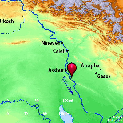
Atlas  Tigris River and surrounding area Maps Created using Biblemapper 3.0 Additional data from OpenBible.info Occurrences Genesis 2:14 The name of the third river is Hiddekel: this is the one which flows in front of Assyria. The fourth river is the Euphrates.Daniel 10:4 In the four and twentieth day of the first month, as I was by the side of the great river, which is Hiddekel, Encyclopedia TIGRISti'-gris (Tigris, the Greek equivalent of the Hebrew chiddeqel): One of the rivers of Eden going "eastward to Assyria" (Genesis 2:14 margin), called the Great River (Daniel 10:4), elsewhere mentioned in the apocryphal books, as in Tob 6:1; Judith 1:6; Ecclesiasticus 24:25, called Diglath in Josephus, and Diglit in Pliny, now called in Mesopotamia Dijleh, generally supposed to be a Semitic corruption of Tigra, meaning originally an arrow, which from its rapidity of motion is symbolized. The Tigris rises in the mountains of Armenia, latitude 38 degrees 10 minutes, longitude 39 degrees 20 minutes, only a few miles from the main branch of the Euphrates. After pursuing a tortuous southeasterly course for 150 miles, it is joined by the east branch at Osman Kieui, some distance below Diarbekr. Here the stream is 450 ft. wide and 3 or 4 ft. deep. Passing through numerous mountain gorges for another 150 miles, it emerges into the region of low hills about Nineveh, and a little below into the great alluvial plain of Mesopotamia. Thence in its course to Bagdad it is joined by the Great Zab, the Lesser Zab, the Adhem, and the Diyaleh rivers, bringing a large amount of water from the Zagros Mountains. At Bagdad the overflows from the Euphrates in high water often increase the inundations. The flood season begins early in the month of March, reaching its climax about May 1, declining to its natural level by midsummer. In October and November, the volume of water increases considerably, but not so much as to overflow its banks. Below Bagdad, throughout the region of Babylonia proper, the Tigris joins with the Euphrates in furnishing the water for irrigation so successfully used in ancient times. English engineers are at present with great promise of success aiming to restore the irrigating systems of the region and the prosperity of ancient times. The total length of the river is 1,146 miles. It now joins the Euphrates about 40 miles Northwest of the Persian Gulf, the two streams there forming the Shat el Arab, but in early historical times they entered the Persian Gulf by separate mouths, the Gulf then extending a considerable distance above the present junction of the rivers, the sediment of the streams having silted up the head of the Gulf to that distance. HID'DEKEL, now called The Tigris, a river of western Asia, running, part way, parallel with the Euphrates. Its sources are in Armenia, its whole course, until its union with the Euphrates, is 1146 ms., after that it unites with the Euphrates and this union continues 100 ms. to the Persian Gulf. It is navigable 600 ms. for small vessels drawing from three to four ft. of water. On its eastern bank is the city of Nineveh. Its name in the ancient Zend language was Teger, meaning "stream", whence it became Tigris. Strong's Hebrew H2313: ChiddeqelHiddekel, ancient name of a Mesopotamian river |


