Atlas 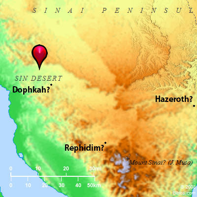 Sin Desert and surrounding area
Maps Created using Biblemapper 3.0Additional data from OpenBible.infoOccurrences Exodus 16:1 They took their journey from Elim, and all the congregation of the children of Israel came to the wilderness of Sin, which is between Elim and Sinai, on the fifteenth day of the second month after their departing out of the land of Egypt. Exodus 16:3 and the children of Israel said to them, "We wish that we had died by the hand of Yahweh in the land of Egypt, when we sat by the meat pots, when we ate our fill of bread, for you have brought us out into this wilderness, to kill this whole assembly with hunger." Exodus 16:6 Moses and Aaron said to all the children of Israel, "At evening, then you shall know that Yahweh has brought you out from the land of Egypt; Exodus 16:32 Moses said, "This is the thing which Yahweh has commanded,'Let an omer-full of it be kept throughout your generations, that they may see the bread with which I fed you in the wilderness, when I brought you forth from the land of Egypt.'" Encyclopedia WANDERINGS OF ISRAELwon'-der-ingz:
I. CONDITIONS
1. The Wilderness
2. Four Separate Regions Included
3. "The Sandy Tract"
4. Description of the Arabah
5. Physical Condition of the Wilderness
6. Difficulties Regarding the Numbers of Israel and Account of Tabernacle
7. Difficulty as to Number of Wagons
8. Fauna of the Desert
9. Characteristic Names of the Districts
II. FIRST JOURNEY
1. Mode of Traveling
2. The Route: the First Camp
3. Waters of Marah
4. Camp by the Red Sea
5. The Route to Sinai
III. SECOND JOURNEY
1. The Stay at Sinai
2. Site of Kadesh-barnea
3. The Route: Hazeroth to Moseroth
4. The Camps between Hazeroth and Moseroth
IV. THE THIRTY-EIGHT YEARS
1. The History
2. The Camps Visited
V. THE FINAL JOURNEY
1. The Route
2. The Five Stations to the Border of Moab
3. From Iyim to Arnon
4. The Message to Sihon
5. From the Arnon to Shittim
6. Review
I. Conditions.
1. The Wilderness:
A consideration of the geography and natural features of the desert between Egypt and Edom, in which the Hebrews are said to have wandered for 40 years, has a very important bearing on the question of the genuineness of the Pentateuch narrative. This wilderness forms a wedge between the Gulfs of Suez and `Aqabah, tapering South to the granite mountains near Sinai. It has a base 175 miles long East and West on the North, and the distance North and South is 250 miles. The area is thus over 20,000 square miles, or double the size of the Promised Land East and West of Jordan. On the North of this desert lie the plains of Gaza and Gerar, and the Neghebh or "dry region" (the south; see Numbers 13:17 the Revised Version (British and American)), including the plateau and low hills round Beersheba.
2. Four Separate Regions Included:
There are four separate regions included in the area, the largest part (13,000 square miles) being a plateau which on the South rises 3,000 to 4,000 feet above the sea, and shelves gently toward the Philistine plains. It is drained into the broad Wady el-`Arish, named from el-`Arish ("the booth"), a station on the Mediterranean coast South of Gaza, where this valley enters the sea. In this direction several prominent mountains occur (Jebel Yeleq, Jebel Hilal, and Jebel Ikhrimm), while further East-near the site of the Western Kadesh-there is a step on the plateau culminating on the South in Jebel el-Mukhrah; but none of these ranges appears to be more than about 4,000 feet above the sea. The plateau is known as Badiet et-Tih ("the pathless waste"), and though some Arab geographers of the Middle Ages speak of it as the desert "of the wandering of the Beni Israil," they refer to the whole region as far as `Aqabah, and not to the plateau alone. The elevation on the South forms a very steep ascent or "wall" (see SHUR), bending round on the West and East, and rising above the shore plains near Suez and the `Arabah near Edom. Near the center of the plateau is the small fort of Nakhl ("the palms"), where water is found; but, as a whole, the Tih is waterless, having very few springs, the most important being those near the western Kadesh (`Ain Kadis); for Rehoboth belongs to the region of the Neghebh rather than to the Tih. In winter, when very heavy rains occur, the valleys are often flooded suddenly by a seil, or "torrent," which is sometimes 10 feet deep for a few hours. Such a seil has been known to sweep away trees, flocks, and human beings; yet, in consequence of the hard rocky surface, the flood rushes away to the sea and soon becomes a mere rivulet. Where soft soil is found, in the valleys, grass will grow and afford pasture, but even early in spring the Arabs begin to suffer from want of water, which only remains in pits and in water holes among rocks. They have then much difficulty in watering their goats and sheep.
3. "The Sandy Tract":
Below the Tih escarpment on the South is another region called Debbet er-ramleh ("the sandy tract"), which is only 20 miles across at its widest; and to the West are the sandy plains, with limestone foothills, stretching East of the Bitter Lakes and of the Gulf of Suez. The third region consists of the granite chain (see SINAI) which rises to 8,550 feet above the sea, and some 6,000 feet above its valleys, near Jebel Musa. Parts of this region are better watered than is any part of the Tih, and the main route from Egypt to Edom has consequently always run through it.
4. Description of the Arabah:
The fourth region is that of the `Arabah, or broad valley (10 miles wide) between the Gulf of `Aqabah and the Dead Sea. It has a watershed some 700 feet high above the Gulf (South of the neighborhood of Petra); and North of this shed the water flows to the Dead Sea 1,292 feet below the Mediterranean. The total length of this valley is 120 miles, the watershed being (near the Edomite chain) about 45 miles North of `Aqabah. The head of the Gulf was once farther North; and, near `Ain Ghudian (probably Eziongeber) and `Ain et-Tabah (probably Jotbath), there is a mud flat which becomes a lake in winter-about 20 miles from the sea. Lower down-at `Ain edition Deffiyeh-there is another such flat, the head being 10 miles from `Aqabah. The whole region is much better watered than either of the three preceding districts, having springs at the foot of the mountains on either side; and the `Arabah is thus the best pastoral country within the limits described. It now supports a nomad population of about 2,000 or 3,000 souls (Chaiwatat and `Alawin Arabs), while the region round Sinai has some 2,000 souls (Towarah Arabs): the whole of the Tih has probably not more than 5,000 inhabitants; for the stronger tribes (`Azazimeh and Terabin) live chiefly between Gaza and Beersheba. These Arabs have goats, sheep and camels, but cattle are only found near Beersheba. The flocks are watered daily-as in Palestine generally-and are sometimes driven 20 miles in winter to find pasture and water. The water is also brought on donkeys and camels to the camps, and carried in goatskin bags on a journey through waterless districts.
See also ARABAH.
5. Physical Condition of the Wilderness:
There is no reason to think that the conditions at the time of the Exodus differed materially from those of the present time. The Arabs have cut down a good many acacia trees for firewood in recent times, but the population is too small materially to affect the vegetation. The annual rainfall-except in years of drought-is from 10 to 20 inches, and snow falls in winter on the Tih, and whitens Sinai and the Edomite mountains for many days. The acacia, tamarisk and palm grow in the valleys. At Wady Feiran there are said to be 5,000 date palms, and they occur also in the `Arabah and the Edomite gorges, while the white broom (1 Kings 19:5, the King James Version "juniper") grows on the Tih plateau. This Tih plateau is the bed of an ancient ocean which once surrounded the granite mountains of Sinai. It was upheaved probably in the Miocene age, long before man appeared on earth. The surface formation (Hull, Memoir on the Geology and Geography of Arabia-Petraea, etc., 1886) consists of Cretaceous limestones of the Eocene and Chalk ages, beneath which lies the Nubian sandstone of the Greensand period, which is also visible all along the route from Sinai to `Aqabah, and on the east side of the Dead Sea, and even at the foot of the Gilead plateau. These beds are all visible in the Tih escarpment; and North of Sinai there are yet older formations of limestone, and the "desert sandstone" of the Carboniferous period. Since the conditions of natural water-supply depend entirely on geological formation and on rainfall, neither of which can be regarded as having changed since the time of Moses, the scientific conclusion is that the desert thus described represents that of his age, This, as we shall see, affects our conclusion as to the route followed by Israel from Egypt to the `Arabah; for, on the direct route from Suez to Nakhl (about 70 miles), there is no water for the main part of the way, so it has to be carried on camels; while, East of Nakhl, in a distance of 80 miles, there is only one known supply in a well (Bir eth-Themed) a few miles South of the road. This route was thus practically impassable for the Hebrews and their beasts, whereas the Sinai route was passable. Thus when Wellhausen (History of Israel and Judah, 343) speaks of Israel as going straight to Kadesh, and not making a "digression to Sinai," he seems not to have considered the topography as described by many modern travelers. For not only was the whole object of their journey first to visit the "Mount of God," but it also lay on the most practicable route to Kadesh.
6. Difficulties Regarding the Numbers of Israel and Account of Tabernacle
It is true that there are certain difficulties as regards both the numbers of Israel and the account of the tabernacle. The first of these objections has been considered elsewhere (see EXODUS). The detailed account of the tabernacle (Exodus 25-28; 36-39) belongs to a part of the Pentateuch which many critical writers assign to a later date than that of the old narrative and laws (Exodus 1-24). The description may seem more applicable to the semi-permanent structure that existed at Shiloh and Nob, than to the original "tent of meeting" in the desert. On the other hand, living so long in civilized Egypt, the Hebrews no doubt had among them skilled artificers like Bezalel. The Egyptians used acacia wood for furniture; and though the desert acacia does not grow to the size which would furnish planks 1 1/4 cubits broad, it may be that these were made up by joiner's work such as the ancients were able to execute. There was plenty of gold in Egypt and Asia, but none near Sinai. It is suggested, however, that the ornaments of which the Hebrews spoiled the Egyptians were presented, like the stuffs (Exodus 36:6) prepared for the curtains-just as the Arabs weave stuffs for their tents-and they might have served to spread a thin layer of gold over acacia boards, and on the acacia altar. It is more difficult to understand (on our present information) where silver enough for the bases (Exodus 26:25) would be found. Copper (Exodus 27:4) presents less difficulty, since there were copper mines in Wady Nucb near Serabit el Khadim. The women gave gold earrings to Aaron (Exodus 32:3) for the Golden Calf, but this may have been a small object. Eusebius (in Onomasticon), referring to Dizahab, "the place of gold" (Deuteronomy 1:1), now Dhahab ("gold") on the west shore of the Gulf of `Aqabah, East of Sinai, mentions the copper mines of Punon; and thought that veins of gold might also have existed in the mountains of Edom in old times. A little gold is also found in Midian. We know that the Egyptians and Assyrians carried arks and portable altars with their armies, and a great leather tent of Queen Habasu actually exists. Thothmes III, before the Exodus, speaks of "seven tent poles covered with plates of gold from the tent of the hostile king" which he took as spoil at Megiddo. The art of engraving gems was also already ancient in the time of Moses.
See NUMBERS, BOOK OF.
7. Difficulty as to Number of Wagons:
Another difficulty is to understand how six ox wagons (Numbers 7:3) sufficed to carry all the heavy planks and curtains, and vessels of the tabernacle; and though the use of ox carts, and of four-wheeled wagons also, is known to have been ancient in Asia, there are points on even the easiest route which it would seem impossible for wagons to pass, especially on the rough road through Edom and Moab. On the other hand, we know that an Egyptian Mohar did drive his chariot over the mountains in Palestine in the reign of Rameses II, though it was finally broken near Joppa.
8. Fauna of the Desert:
Whatever be thought as to these questions, there are indications in other passages of actual acquaintance with the desert fauna. Although the manna, as described (Exodus 16:31), is said not to resemble the sweet gum which exudes from the twigs of the tamarisk (to which it has been compared by some), which melts in the sun, and is regarded as a delicacy by the Arabs, yet the quail (Exodus 16:13 Numbers 11:31) still migrate from the sea northward across the desert in spring, flying low by night. The birds noticed (Leviticus 11 Deuteronomy 14) include-as Canon Tristram remarked-species found on the seashores and in the wilderness, such as the cormorant, pelican and gull; the ostrich (in the desert East of Moab); the stork, the crane and the heron which migrate from Africa to the Jordan valley. It is notable that, except the heron (Assyrian anpatu), the Hebrew names are not those used by later Assyrians. The mammals include the boar which loves the marshes, and the hyrax (the King James Version "coney") which still exists near Sinai and in the desert of Judah, with the desert hare. It is remarkable that in Deuteronomy (14:5), besides the ibex and the bubak, two species are added (the fallow deer, Hebrew 'ayyal, the King James Version "hart," and the roebuck, Hebrew yachmur, Arabic yachmur, the King James Version "fallow deer") which are not desert animals. The former occurs at Tabor; the latter was found by the present writer in 1873 on Carmel, and is since known in Gilead and Lebanon. But Deuteronomy refers to conditions subsequent to the capture of Gilead and Bashan.
9. Characteristic Names of the Districts:
The various districts in the desert receive characteristic names in the account of the Exodus. Thus, Shur is the coast region under the "wall" of the Tih, and Sin (Exodus 17:1 Numbers 33:11) was the "glaring" desert (see SINAI) of white chalk, West of Sinai. Paran is noticed 10 times, as a desert and mountain region (Deuteronomy 33:2 Habakkuk 3:3) between Sinai and Kadesh. The name seems to survive in Wady Feiran West of Sinai. It means some kind of "burrows," whether referring to mines, caves or water pits, according to the usual explanation; but in Arabic the root also means "hot," which is perhaps more likely. The term seems to be of very wide extension, and to refer to the Tih generally (Genesis 21:21); for David (1 Samuel 25:1) in Paran was not far from Maon and Carmel South of Hebron, and the same general application (1 Kings 11:18) is suggested in another passage. Finally the desert of Zin (tsin) is noticed 9 times, and very clearly lay close to Kadesh-barnea and East of Paran (Numbers 13:21; Numbers 20:1; Numbers 34:3 Deuteronomy 32:51 Joshua 15:3). The rabbis rendered it "palm" (tsin), which is appropriate to the `Arabah valley which still retains the old name mentioned in Deuteronomy 1:1. These various considerations as to the conditions to be fulfilled may serve to show that the difficulties often raised, as to the historic character of the Exodus narrative, have been much overstated; and a further study of the various journeys serves to confirm this view.
II. First Journey.
1. Mode of Traveling:
Israel left Egypt in the early part of April (after the 14th of Abib) and reached Sinai about the 14th or 19th of the 3rd month (Exodus 19:1), or at the end of May. They thus took two months to accomplish a journey of about 117 miles; but from the first camp after crossing the Red Sea to that in the plain before the Mount ten marches are mentioned, giving intervals of less than 12 miles between each camp. Thus they evidently remained in camp for at least 50 days of the time, probably at the better supplied springs, including that of the starting-point, and those at Elim and Rephidim, in order to rest their flocks. The camps were probably not all crowded round one spring, but spread over a distance of some miles. The Arabs indeed do not camp or keep their flocks close to the waters, probably in order not to defile them, but send the women with donkeys to fetch water, and drive the sheep and goats to the spring or well in the cool of the afternoon. Thus we read that Amalek "smote the hindmost" (Deuteronomy 25:18), which may either mean the stragglers unable to keep up when "weary," or perhaps those in the camp most in the rear.
2. The Route: the First Camp:
The route of Israel has been very carefully described by Robinson (BR, 1838, I, 60-172; II, 95-195), and his account is mainly followed in this and the next sections. We may place the first camp (see EXODUS), between the springs which supply Suez (`Ain Nab'a and `Ayyun Musa), which are about 4 miles apart. The first of these is scooped out among the sand hillocks, and bubbles up in a basin some 6 ft. deep. The water is brackish, but supplies as many as 200 camel loads at once for Suez. At `Ayyun Musa ("the springs of Moses") there are seven springs, some being small and scooped in the sand. A few palms occur near the water (which is also brackish), and a little barley is grown, while in recent times gardens of pomegranates have been cultivated (A. E. Haynes, Man-Hunting in the Desert, 1894, 106), which, with the palms, give a grateful shade.
3. Waters of Marah:
From this base Israel marched "three days in the wilderness" of Shur, "and found no water" (Exodus 15:22). They no doubt carried it with them, and may have sent back camels to fetch it. Even when they reached the waters of Marah ("the bitter") they found them undrinkable till sweetened. The site of Marah seems clearly to have been at `Ain Chawarah ("the white chalk spring"), named from the chalky mound beside it. This is 36 miles from `Ayyun Musa, giving an average daily march of 12 miles. There is no water on the route, though some might have been fetched from `Ain Abu Jerad in Wady Sudr, and from the small spring of Abu Suweirah near the sea. Burckhardt thought that the water was sweetened from the berries of the Gharqad shrub (which have an acid juice) on the thorny bushes near the spring. This red berry ripens, however, in June. There is no doubt, on the other hand, that the best treatment for brack water is the addition of an acid taste. The Arabs consider the waters of this spring to be the most bitter in the country near.
4. Camp by the Red Sea:
From Marah, the next march led to Elim ("the palms"), where were "twelve springs (not "wells") of water and seventy palms." The site seems clearly to have been in Wady Gharandil, where a brook is found fed by springs of better water than that of Marah. The distance is only about 6 miles, or an easy march, and palm trees exist near the waters. Israel then entered the desert of Sin, stretching from Elim to Sinai, reaching a camp "by the Red Sea" (Numbers 33:10) just a month after leaving Egypt (Exodus 16:1). The probable site is near the mouth of Wady et-Taiyibeh ("the goodly valley"), which is some 10 or 12 miles from the springs of Gharandil. The foothills here project close to the coast, and North of the valley is Jebel Chammam Far'aun ("the mountain of Pharaoh's hot bath"), named from hot sulphur springs. The water in Wady et-Taiyibeh is said to be better than that of Marah, and this is the main Arab watering-place after passing Gharandil. A small pond is here described by Burckhardt at el-Murkhat, in the sandstone rock near the foot of the mountains, but the water is bitter and full of weeds, moss and mud. The site is close to a broad shore plain stretching South Here two roads diverge toward Sinai, which lies about 65 miles to the Southeast, and in this interval (Numbers 33:11-15) five stations are named, giving a daily march of 13 miles. The Hebrews probably took the lower and easier road, especially as it avoided the Egyptian mines of Wady el-Maghdrah ("valley of the cave") and their station at Serabit el-Khadim ("pillars of the servant"), where-though this is not certain-there may have been a detachment of bowmen guarding the mines.
5. The Route to Sinai:
None of the five camps on this section of the route is certainly known. Dophkah apparently means "overdriving" of flocks, and Alush (according to the rabbis) "crowding," thus indicating the difficulties of the march. Rephidim ("refreshments") contrasts with these names and indicates a better camp. The site, ever since the 4th century A.D., has always been shown in Wady Feiran (Eusebius, Onomasticon, under the word "Rephidim")-an oasis of date palms with a running stream. The distance from Sinai is about 18 miles, or 14 from the western end of the broad plain er-Rachah in which Israel camped in sight of Horeb; and the latter name (Exodus 17:6) included the Desert of Sinai even as far West as Rephidim. Here the rod of Moses, smiting the rock, revealed to the Hebrews an abundant supply, just as they despaired of water. Here apparently they could rest in comfort for some three weeks before the final march to the plain "before the mount" (Exodus 19:1, 2), which they reached two months after leaving Egypt. Here Amalek-coming down probably from the mines-attacked them in the rear. Meanwhile there was ample time for the news of their journey to reach Midian, and for the family of Moses (Exodus 18:1-5) to reach Sinai. On one of the low hills near Wady Feiran, Moses watched the doubtful fight and built his stone altar. A steep pass separates the oasis from the Rachah plain, and baggage camels usually round it on the North by Wady esh-Sheikh, which may have been the actual route. The Rephidim oasis has a fertile alluvial soil, and the spot was chosen by Christian hermits perhaps as early as the 3rd century A.D.
III. Second Journey.
1. The Stay at Sinai:
Israel remained at Mt. Sinai for 10 months, leaving it after the Passover of the "second year" (Numbers 9:1-3), and apparently soon after the feast, since, when they again witnessed the spring migration of the quail (Numbers 11:31) "from the sea"-as they had done in the preceding year (Exodus 16:13) farther West-they were already about 20 miles on their road, at Kibroth-hattaavah, or "the graves of lust."
2. Site of Kadesh-barnea:
(1) In order to follow their journey it is necessary to fix the site of Kadesh-barnea to which they were going, and there has been a good deal of confusion as to this city since, in 1844, John Rowlands discovered the site of the western Kadesh, at `Ain Qadis in the northern part of the Tih. Robinson pointed out (BR, II, 194, note 3) that this site could not possibly be right for Kadesh-barnea; and, though it was accepted by Professor Palmer, who visited the vicinity in January, 1870, and has been advocated by Henry Clay Trumbull (Kadesh-barnea, 1884), the identification makes hopeless chaos of the Old Testament topography. The site of `Ain Qadis is no doubt that of the Kadesh of Hagar (see SHUR), and a tradition of her presence survives among the Arabs, probably derived from one of the early hermits, since a small hermitage was found by Palmer in the vicinity (Survey of Western Palestine, Special Papers, 1881, 19). But this spring is not said to have been at the "city" of Kadesh-barnea, which is clearly placed at the southeast corner of the land of Israel (Joshua 15:3), while, in the same chapter (Joshua 15:23), another site called Kedesh is mentioned, with Adadah (`Ada'deh 7 miles Southeast of Arad) and Hazor (at Jebel Chadireh); this Kedesh may very well have been at the western Kadesh.
(2) Kadesh-barnea is noticed in 10 passages of the Old Testament, and in 16 other verses is called Kadesh only. The name probably means "the holy place of the desert of wandering," and-as we shall see-the wanderings of Israel were confined to the `Arabah. The place is described as "a city in the uttermost.... border" of Edom (Numbers 20:16), Edom being the "red land" of Mt. Seir, so called from its red sandstones, as contrasted with the white Tih limestone. It is also very clearly placed (Numbers 34:3, 4) South of the Dead Sea (compare Joshua 15:3), while Ezekiel also (47:19) gives it as the southeastern limit of the land, opposed to Tamar (Tamrah near Gaza) as the southeastern border town. A constant tradition, among Jews and Christians alike, identifies Kadesh-barnea with Petra, and this as early as the time of Josephus, who says that Aaron died on a mountain near Petra (Ant., IV, iv, 7), and that the old name of Petra was Arekem (vii, 1). The Targum of Onkelos (on Numbers 34:4) renders Kadesh-barnea by "Rekem of the G'aia" and this name-meaning "many-colored"-was due to the many-colored rocks near Petra, while the g'aia or "outcry" is probably that of Israel at Meribah-kadesh (Numbers 27:14), and may have some connection with the name of the village el-Jii, at Petra, which is now called Wady Musa ("the valley of Moses") by the Arabs, who have a tradition that the gorge leading to Petra was cloven by the rod of Moses when he struck the rock at the "waters of strife" (Numbers 27:14), forming the present stream which represents that of "Meribah of Kadesh." Eusebius also (in Onomasticon under the word "Barne") connects Kadesh with Petra, and this traditional site so fully answers the requirements of the journey in question that it may be accepted as one of the best-fixed points on the route, especially as the position of Hazeroth agrees with this conclusion. Hazeroth (Numbers 11:35; Numbers 12:16; Numbers 33:17 Deuteronomy 1:1) means "enclosures," and the name survives at `Ain Chadrah ("spring of the enclosure") about 30 miles Northeast of Mt. Sinai on the way to the `Arabah. It was the 3rd camp from Sinai, the 1st being Taberah (Numbers 11:3) and the 2nd Kibroth-hattaavah (Numbers 11:35), giving a daily march of 10 miles.
See KADESH-BARNEA.
3. The Route: Hazeroth to Moseroth:
After passing Hazeroth (Numbers 12:16; Numbers 13:3) the journey appears to have been leisurely, and Israel probably camped for some time in the best pastures of the `Arabah. For the spies were sent from Paran near Hazeroth to explore the route to Kadesh, and to examine the "south country" through which Israel hoped to enter Palestine (Numbers 13:17, 21). They explored this district (Numbers 13:21; Numbers 32:8) from "the wilderness of Zin," or otherwise "from Kadesh-barnea," on the East, to Rehob-probably Rehoboth (now er-Ruheibeh)-on the West; and-having been absent 40 days (Numbers 13:25)-after visiting Hebron (Numbers 13:22) they returned by the direct route leading South of Arad (Tell `Arad) to Petra, which road is called (Numbers 21:1) the "way of the spies." On their return, in the season of "first-ripe grapes" (Numbers 13:20), they found Israel at Kadesh (Numbers 13:26). No place North of Hebron is mentioned in the account of their explorations, and it is difficult to suppose that, in 40 days, they could have reached the Syrian city of Hamath, which is some 350 miles North of Petra, and have returned thence. The definition of Rehob (mentioned before Hebron) as being `on the coming to Hamath' (Numbers 13:21) is best explained as a scribe's error, due to an indistinct manuscript, the original reading being chalatseth, and referring to the classical Elussa (now Khalasah) which lies 10 miles North of Rehoboth on the main road to Beersheba and Hebron. Israel left Sinai in the spring, after the Passover, and was near Hazeroth in the time of the quail migration. Hazeroth possesses the only perennial supply of water in the region, from its vicinity the spies set forth in August.
4. The Camps between Hazeroth and Moseroth:
Most of the sites along this route are unknown, and their position can only be gathered from the meaning of the names; but the 6th station from Hazeroth was at Mt. Shepher (Numbers 33:23), and may have left its name corrupted into Tell el-`Acfar (or `Asfar), the Hebrew meaning "the shining hill," and the Arabic either the same or else "the yellow." This site is 60 miles from Hazeroth, giving a daily march of 10 miles. As regards the other stations, Rithmah means "broomy," referring to the white desert broom; Rimmon-perez was a "cloven height," and Libnab a "white" chalky place; Rissah means "dewy," and Kehelathah, "gathering." From Mt. Shepher the distance to the vicinity of Mt. Hor is about 55 miles, and seven stations are named, giving an average march of 8 miles. The names are Haradah (Numbers 33:24), "fearful," referring to a mountain; Makheloth, "gatherings"; Tahath-probably "below"-marking the descent into the `Arabah; Terah, "delay," referring to rest in the better pastures; Mithkah, "sweetness" of pasture or of water; Hashmonah, "fatness"; and Moseroth; probably meaning "the boundaries," near Mt. Hor. These names, though now lost, agree well with a journey through a rugged region of white limestone and yellow sandstone, followed by a descent into the pastoral valley of the `Arabah. The distances also are all probable for flocks. Read Complete Article... |