Encyclopedia
KIRkur, kir (kir):
1. Meaning:
The meaning of Kir is "inclosure" or "walled place," and it is therefore doubtful whether it is a place-name in the true sense of the word. In 2 Kings 16:9 it is mentioned as the place whither Tiglath-pileser IV carried the Syrian (Aramean) captives which he deported from Damascus after he had taken that city. In Amos 1:5 the prophet announces that the people of Syria (Aram) shall go into captivity unto Kir, and in 9:7 it is again referred to as the place whence the Lord had brought the Syrians (Arameans) as Israel had been brought out of Egypt, and the Philistines from Caphtor.
2. How Rendered in the Septuagint:
Except in one manuscript (Septuagint, Codex Alexandrinus), where it appears as the Libyan Cyrene (2 Kings 16:9), it is never rendered in the Septuagint as a place-name. Thus the place whence the Syrians were brought (Amos 9:7) is not Kir, but "the deep" or "the ditch" Septuagint ek bothrou, "pit"), probably a translation of some variant rather than of the word "Kit" itself. Comparing the Assyrian-Babylonian kiru (for qiru), "wall," "inclosure," "interior," or the like, Kir might have the general meaning of a place parted off for the reception of exiled captives. Parallels would be Kir Moab, "the enclosure of Moab," Kir Heres or Kir Chareseth, "the enclosure of brick" Septuagint hoi lithoi toni toichou). It seems probable that there was more than one place to which the Assyrians transported captives or exiles, and if their practice was to place them as far as they could from their native land, one would expect, for Palestinian exiles, a site or sites on the eastern side of the Tigris and Euphrates.
3. An Emendation of Isaiah 22:5:
In Isaiah 22:5 occurs the phrase, "a breaking down of the walls, and a crying to the mountains" (meqarqar qir we-shoa` 'el ha-har-"a surrounding of the wall," etc., would be better), and the mention of qir and shoa` here has caused Fried. Delitzsch to suggest that we have to read, instead of qir, qoa`, combined with shoa`, as in Ezekiel 23:23. Following this, but retaining qir, Cheyne translates "Kir undermineth, and Shoa is at the mount," but others accept Delitzsch's emendation, Winckler conjecturing that the rendering should be "Who stirreth up Koa` and Shoa` against the mountain" (Alttest. Untersuchungen, 177). In the next verse (Isaiah 22:6) Kir is mentioned with Elam-a position which a city for western exiles would require.
4. Soldiers of Kir in Assyrian Army:
The mention of Elam as taking the quiver, and Kir as uncovering the shield, apparently against "the valley of the vision" (in or close to Jerusalem), implies that soldiers from these two places, though one might expect them to be hostile to the Assyrians in general, were to be found in their armies, probably as mercenaries. See Fried. Delitzsch, Wo lag das Paradies? 233; Schrader, COT, 425.
T. G. Pinches
KIR OF MOAB
(qir moa'-abh; Septuagint has to teichos, "the wall," "fortress"):
1. Identification:
The name, at least in this form, appears only once (Isaiah 15:1) as that of a city in Moab. It is named with Ar of Moab, with which possibly it may be identical, since `ar or `ir is the Hebrew equivalent of the Moabite Qir. The Targum hence reads "Kerak in Moab." There can be no doubt that the Kerak here intended is represented by the modern town of that name, with which, consequently, Kir Moab is almost universally identified. It must always have been a place of importance. It is mentioned as Charakmoba (Karakmoba) in the Acts of the Council of Jerusalem (536 A.D.) and by the early geographers. It dominated the great caravan road connecting Syria with Egypt and Arabia. The Crusaders therefore directed attention to it, and held possession from 1167 till it fell again into the hands of the Moslems under Saladin, 1188. The Chroniclers speak of it as in el Belqa, and the chief city of Arabia Secunda. Under the title of Petra Deserti the Crusaders founded here a bishop's see. The Greek bishop of Petra still has his seat in Kerak.
2. Discription:
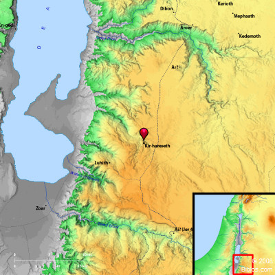
Kerak stands upon a lofty spur projecting westward from the Moab plateau, with Wady `Ain Franjy on the South, and Wady el-Kerak on the North, about 10 miles from the Dead Sea. The sides of the mountain sink sharply into these deep ravines, which unite immediately to the West, and, as Wady el-Kerak, the great hollow runs northwestward to the sea. It is a position of great natural strength, being connected with the uplands to the East only by a narrow neck. It is 3,370 ft. above the level of the sea. The mountains beyond the adjacent valleys are much higher. The place was surrounded by a strong wall, with five towers, which can still be traced in its whole length. The most northerly tower is well preserved. The most interesting building at Kerak is the huge castle on the southern side. It is separated from the adjoining hill on the right by a large artificial moat; and it is provided with a reservoir. A moat also skirts the northern side of the fortress, and on the East the wall has a sloped or battered base. The castle is then separated from the town. The walls are very thick, and are well preserved. Beneath the castle is a chapel in which traces of frescoes are still visible. In days of ancient warfare the place must have been practically impregnable. It could be entered only by two roads passing through rock-cut tunnels. The main danger must always have been failure of water supply. There are springs immediately outside the city; but those alone would not be sufficient. Great cisterns were therefore constructed in the town and also in the castle. The half-nomadic inhabitants of Kerak today number some 1,140 families (Musil, Arabia Petrea, III, 97). The Greek church claims about 2,000 souls; the rest are Moslems. They are wild and fearless people, not greatly inclined to treat strangers with courtesy and kindness. In the spring of 1911 the town was the center of a rising against the government, which was not quelled until much blood had been shed.
W. Ewing