Encyclopedia
SINAIsi'-ni, si'-na-i (cinay; Codex Alexandrinus Sina, Codex Vaticanus Seina):
1. The Name:
The name comes probably from a root meaning "to shine," which occurs in Syriac, and which in Babylonian is found in the name sinu for "the moon." The old explanation, "clayey," is inappropriate to any place in the Sinaitic desert, though it might apply to Sin (Ezekiel 30:15, 16) or Pelusium; even there, however, the applicability is doubtful. The desert of Sin (Exodus 16:1; Exodus 17:1 Numbers 33:11 f) lay between Sinai and the Gulf of Suez, and may have been named from the "glare" of its white chalk. But at Sinai "the glory of Yahweh was like devouring fire on the top of the mount in the eyes of the children of Israel" (Exodus 24:17); and, indeed, the glory of the Lord still dyes the crags of Jebel Musa (the "mountain of Moses") with fiery red, reflected from its red granite and pink gneiss rocks, long after the shadows have fallen on the plain beneath. Sinai is mentioned, as a desert and a mountain, in 35 passages of the Old Testament. In 17 passages the same desert and mountain are called "Horeb," or "the waste." This term is chiefly used in Deuteronomy, though Sinai also occurs (Deuteronomy 33:2). In the other books of the Pentateuch, Sinai is the usual name, though Horeb also occurs (Exodus 3:1; Exodus 17:6; Exodus 33:6), applying both to the "Mount of God" and to the desert of Rephidim, some 20 miles to the Northwest.
2. Traditional Site:
The indications of position, in various passages of the Pentateuch, favor the identification with the traditional site, which has become generally accepted by all those explorers who have carefully considered the subject, though two other theories may need notice. Moses fled to the land of Midian (or "empty land"), which lay East of the Sinaitic peninsula (Numbers 22:4, 7; Numbers 25; Numbers 25 31), and when he wandered with his flocks to Horeb (Exodus 3:1) he is said to have reached the west side of the desert. In another note (Deuteronomy 1:2) we read that the distance was "eleven days' journey from Horeb by the way of Mount Seir unto Kadesh-barnea" or Petra (see WANDERINGS OF ISRAEL), the distance being about 145 miles, or 14 miles of daily march, though Israel-with its flocks, women and children-made 16 marches between these points. Sinai again is described as being distant from Egypt "three days' journey into the wilderness" (Exodus 5:3), the actual route being 117 miles, which Israel accomplished in 10 journeys. But, for Arabs not encumbered with families and herds, this distance could still be covered by an average march of 39 miles daily, on riding camels, or even, if necessary, on foot.
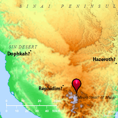
3. Identification with Jebel Musa:
These distances will not, however, allow of our placing Sinai farther East than Jebel Musa. Lofty mountains, in all parts of the world, have always been sacred and regarded as the mysterious abode of God; and Josephus says that Sinai is "the highest of all the mountains thereabout," and again is "the highest of all the mountains that are in that country, and is not only very difficult to be ascended by men, on account of its vast. altitude but because of the sharpness of its precipices: nay, indeed, it cannot be looked at without pain of the eyes, and besides this it was terrible and inaccessible, on account of the rumor that passed about, that God dwelt there" (Ant., II, xii, 1; III, v, 1). Evidently in his time Sinai was supposed to be one of the peaks of the great granitic block called et Tur-a term applying to any lofty mountain. This block has its highest peak in Jebel Katarin (so named from a legend of Catherine of Egypt), rising 8,550 ft. above the sea. Northeast of this is Jebel Musa (7, 370 ft.), which, though less high, is more conspicuous because of the open plain called er Rachah ("the wide") to its Northwest. This plain is about 4 miles long and has a width of over a mile, so that it forms, as Dr. E. Robinson (Biblical Researches, 1838, I, 89) seems to have been the first to note, a natural camp at the foot of the mountain, large enough for the probable numbers (see EXODUS, 3) of Israel.
4. Description of Jebel Musu:
Jebel Musa has two main tops, that to the Southeast being crowned by a chapel. The other, divided by gorges into three precipitous crags, has the Convent to its North, and is called Ras-es-Cafcafeh, or "the willow top." North of the Convent is the lower top of Jebel edition Deir ("mountain of the monastery"). These heights were accurately determined by Royal Engineer surveyors in 1868 (Sir C. Wilson, Ordnance Survey of Sinai); and, though it is impossible to say which of the peaks Moses ascended, yet they are all much higher than any mountains in the Sinaitic desert, or in Midian. The highest tops in the Tih desert to the North are not much over 4,000 ft. Those in Midian, East of Elath, rise only to 4,200 ft. Even Jebel Serbal, 20 miles West of Sinai-a ridge with many crags, running 3 miles in length-is at its highest only 6,730 ft. above the sea. Horeb is not recorded to have been visited by any of the Hebrews after Moses, except by Elijah (1 Kings 19:8) in a time of storm. In favor of the traditional site it may also be observed that clouds suddenly formed, or lasting for days (Exodus 24:15 f), are apt to cap very lofty mountains. The Hebrews reached Sinai about the end of May (Exodus 19:1) and, on the 3rd day, "there were thunders and lightnings, and a thick cloud upon the mount" (Exodus 19:16). Such storms occur as a rule in the Sinaitic desert only in December and January, but thunderstorms are not unknown in Palestine even in May.
5. Patristic Evidence:
A constant tradition fixing the site is traceable back to the 4th century A.D. Eusebius and Jerome (Onomasticon, under the word "Choreb") place Horeb near Paran, which in their time was placed (Onomasticon, under the word "Raphidim") in Wady Feiran. Anchorites lived at Paran, and at Sinai at least as early as 365 A.D., and are noticed in 373 A.D., and often later (Robinson, Biblical Res., 1838, I, 122-28); the monastery was first built for them by Justinian in 527 A.D. and his chapel still exists. Cosmas (Topogr. Christ.), in the same reign, says that Rephidim was then called Pharan, and (distinguishing Horeb from Sinai, as Eusebius also does) he places it "about 6 miles from Pharan," and "near Sinai." These various considerations may suffice to show that the tradition as to Horeb is at least as old as the time of Josephus, and that it agrees with all the indications given in the Old Testament.
6. Lepsius' Theory:
Lepsius, it is true (Letters from Egypt, 1842-44), denying the existence of any unbroken tradition, and relying on his understanding of Cosmas, supposed Sinai to be the Jebel Serbal above mentioned, which lies immediately South of Wady Feiran. His main argument was that, visiting Sinai in March, he considered that the vicinity did not present sufficient water for Israel (Appendix B, 303-18). But, on this point, it is sufficient to give the opinion of the late F. W. Holland, based on the experience of four visits, in 1861, 1865, 1867-68.
He says (Recovery of Jerusalem, 524):
"With regard to water-supply there is no other spot in the whole Peninsula which is nearly so well supplied as the neighborhood of Jebel Musa. Four streams of running water are found there: one in Wady Leja; a second in Wady et Tl'ah which waters a succession of gardens extending more than 3 miles in length, and forms pools in which I have often had a swim; a third stream rises to the North of the watershed of the plain of er Rachah and runs West into Wady et Tl'ah; and a fourth, is formed by the drainage from the mountains of Umm Alawy, to the East of Wady Sebaiyeh and finds its way into that valley by a narrow ravine opposite Jebel edition Deir. In addition to these streams there are numerous wells and springs, affording excellent water throughout the whole of the granitie district. I have seldom found it necessary to carry water when making a mountain excursion, and the intermediate neighborhood of Jebel Musa would, I think, bear comparison with many mountain districts in Scotland with regard to its supply of water. There is also no other district in the Peninsula which affords such excellent pasturage."
This is important, as Israel encamped near Sinai from the end of May till April of the next year. There is also a well on the lower slope of Jebel Musa itself, where the ascent begins.
7. Greene's Theory:
Another theory, put forward by Mr. Baker Greene (The Hebrew Migration from Egypt), though accepted by Dr. Sayce (Higher Cricitism, 1894, 268), appears likewise to be entirely untenable. Mr. Greene supposed Elim (Exodus 15:27) to be Elath (Deuteronomy 2:8), now `Ailah at the head of the Gulf of `Akabah; and that Sinai therefore was some unknown mountain in Midian. But in this case Israel would in 4 days (see Exodus 15:22, 23, 27) have traveled a distance of 200 miles to reach Elim, which cannot but be regarded as quite impossible for the Hebrews when accompanied by women, children, flocks and herds.
C. R. Conder